I did loads of research for a thorough road trip around Iceland. This is what I’ve got in text form, but contact me and I’ll happily rave about the place. I’m organizing all my photos for a photo book, but I’ll see how that shapes up for a website post.
Tips for Traveling in Iceland
General: Iceland, a land of raw natural attractions, is quite rural but weirdly tourist-friendly with hotels everywhere. It is always cold but not super cold (20s in winter, low 50s in summer), but Icelandic weather is notoriously fickle.
Seasons: High season is May-Aug., filled with lush greens, sheep, midnight sun, and way too many tourists. Winter has a genuine winter wonderland feel, but days are short, and many roads and trails are closed. You can chase aurora (forecaster: http://en.vedur.is/, but I estimate only 25% chance that clouds and solar conditions favor you) and do wintry tours like snowmobiling, dog-sledding, or ice caves, but pursue commercial tours at your own peril. March/April, when I went, is thawing season, so it’s muddy.
Where to go: Read below but also I MADE A THOROUGH MAP. Reykjavik, the only city, is in the southwest. Visit, in order of priority: the south coast, the nearby Golden Circle loop, the western Snæfellsnes peninsula, the northern Mývatn region, the southern highlands (if summer), the distant northwestern Westfjords, the Eastfjords. Reykjavik itself needs only a day at most. Blue Lagoon? If you like luxury spas, then definitely go. However, wading in mining runoff amongst hundreds of tourists in the least Icelandic attraction for $100 was not for me.
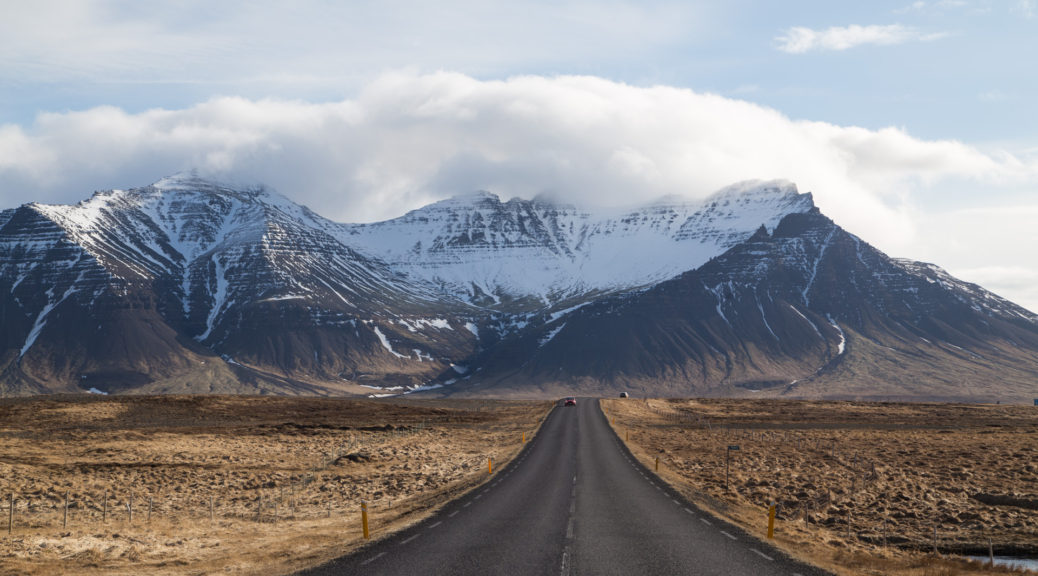
Transportation: you must rent a car. The smaller attractions often have dirt roads, on which AWD passenger cars may offer some comfort. Do not attempt the highland roads (F roads) without a large-type 4×4 (e.g. Range Rover). Gas is expensive: at 206 ISK per liter, it was to ~$11 USD per 100 km/62 mi. Roads are immaculately signed, and they’re simple to navigate because you’ll mostly follow Highway 1, the Ring Road. Check the road conditions map at http://www.road.is/.
Money: USD:ISK = ~1:100 (as of March ’18), easy for mental conversions. Everywhere takes credit card; I used no cash. Restaurants don’t expect tip. Gas stations use chip-and-PIN kiosks, so you can either buy a prepaid card or fill up, walk in, and pay the cashier. Yes, everything is expensive.
Tech: European outlets (two round plugs). Free wifi is basically everywhere. You can get a SIM card and buy a data plan, but I fared fine with offline Google Maps and copious starring.
Food: Restaurant food is delicious, primarily centered around seafood (like arctic char a.k.a. salmon but better) and lamb. If you’re going hostel/grocery store style, look for Bónus (pig on yellow flag) or Nettó (blue) for best prices, but beware limited hours.
Language: Thankfully everyone speaks English because Icelandic is tough. þ/Þ (thorn) is pronounced th as in “thing”. ð/Ð (eth) is pronounced th as in “they” but is typically substituted to “D.” Pronounce J as Y. LL is pronounced with a sort of throttled T-HL sound, but just saying L suffices. Learning a few roots will help make their compound words more intelligible, e.g. Eyjafjallajökull (AY-ya-FYOT-la-YOH-kooh-tl) is ey (island) + fjall (mountain) + jökull (glacier).
I binge-listened to the Saga Thing Podcast while driving alone, but that’s just me.
Attractions
See the map. Bolded names are stronger recommendations. Purple names are highest recommendations.
Capital Region
- Reykjavík
- Sólfarið “sun voyager” [pic] – sculpture of abstract longboat
- Hallgrímskirkja church – the big concrete church
- Harpa concert hall
- Tjörnin – the pond in the middle of old Reykjavik
- Kolaportið – quirky flea market. Weekends only 11 am-5 pm.
- Golden Circle
- Þingvellir “parliament plains” National Park – 2-5 hrs
- old seat of Alþingi “Parliament”
- Almannagjá – dry canyon with Öxarárfoss waterfall
- Can snorkel/scuba in Silfra for $170
- Brúarfoss “bridge waterfall” – 2 hr hike – extremely blue waterfall
- Geysir – 45 min – the geyser after which the rest are named
- Strokkur – erupts every 6 minutes
- Gullfoss “golden waterfall” – 30 min – iconic Niagara-type waterfall
- Þingvellir “parliament plains” National Park – 2-5 hrs
- Kerið “basin” crater – 1 hour- colorful crater to walk around.
- Þjórsárdalur Valley – Contains Hjálparfoss, Háifoss, and Þjófafoss waterfalls.
- Esjan – nearby 914m mountain. Favorite hike of locals
- Reykjadalur – hot spring thermal river, 3 km trail. Was closed when I visited
- Krísuvíkurberg cliffs – sheer cliff on peninsula
- Bláa Lónið “Blue Lagoon” – famous accidental pool turned tourist spa. $90-$100. must pre-book
- Random commercial excursions
- Dog sledding – weekdays, $250 meeting on-site within 2 hours of Reykjavik, unspecified location
- Helicopter tours – $300 to $700 for 20 minutes to 2 hours
- Horse-riding tours
- Snowmobiling
- Ice caving [pic]
South
- Seljalandsfoss waterfall – 1 hr – walkaround waterfall, with Gljúfrabúi, waterfall in crevice, nearby
- Seljavallalaug swimming pool – 40 min from parking – oldest swimming pool in country, fed by natural water.
- Skógafoss waterfall [pic] – 30 min – iconic curtain waterfall, trivial walk
- Fimmvörðuháls (Five Cairn Neck) hike [pic] – 14 mi, 10-12 hr hike between Skógar and Þórsmörk. Starting from Skogafoss: 10 km – winding around the Skoga river to Baldvinsskáli hut. 10 km – Mountain pass between two glaciers. 5 km – Down hike to Þórsmörk.
- Laugavegurinn hike: famed 34 mi hike also starts here.
- Þórsmörk Valley, surrounded by Sólheimajökull/Mýrdalsjökull, Eyjafjallajökull
- Sólheimajökull glacier – 30 min – Many tours come here but can take short 10-min walk to edge
- Sólheimasandur ruined plane – 1 hr from parking – on expansive black sand beach
- Dyrhólaey cliff – 30 min – cliff and bird preserve.
- Reynisfjara beach [pic] – 2 hrs – black sand beach, cliffs = Reynisdrangar.
- Vík í Mýrdal: southern tip town
Southeast
- Fjaðrárgljúfur canyon – 1 hr – steep narrow canyon. Was closed from erosion
- Kirkjugólf – 30 min – “church walk”: flat basalt platform formation
- Skaftafell Region of Vatnajökull National Park – 2-8 hrs
- Svartifoss “black waterfall” – surrounded by basalt columns.
- [pic] Has long adjacent hikes to a glacier valley, to surrounding mountains.
- Jökulsárlón “glacier lagoon” [pic]- 1.5 hrs – famed glacier lagoon with ice floating in water.
- Diamond Beach with ice on black sand beach opposite.
- Höfn: port town past
Eastfjords
- Egilsstaðir: “capital of the east”
- Borgarfjörður Eystri fjord – coastal hiking area (Víknaslóðir Routes) with
- Dyrfjöll mountain.
- Stórurð – tuff boulders, meadows, ponds inside mountains
- Stapavík cove.
- Seyðisfjörður fjord – coastal hiking area with seven summits. Loðmundarfjörður fjord area
- Hengifoss waterfall – 2 hrs roundtrip – “second” tallest waterfall, with red stripes. Litlanesfoss, waterfall with basalt columns along the way.
- Hallormsstaðaskógur forest – 100-year “old growth” forest
North
- Mývatn lake –
- Hverfell “lava mountain” – big explosion crater with 3 km rim hike. Dominates landscape there
- Hverir mud pools – 30 min-3 hr – steam vents. Námafjall mountain, Námaskarð geoactive area
- Viti “hell crater” – 1 hour – filled with blue water, can hike rim. Next to Krafla mountain and power station.
- Skútustaðagígar pseudo-craters – 1 hr – on edge of lake
- Höfði – 1 hr – little park to hike next to strange formations in water
- Dimmuborgir “dark forts” – 2 hrs – well built out walks around lava fields and rock formations
- Grjötagjá cave [pic] – 30 min – crack in earth filled with warm water
- Jarðböðin við Mývatn (Mývatn Nature Baths) – spa with good views. Go late if possible.
- “Diamond Circle”
- Husavik: northern town, whaling capital in the summer
- Ásbyrgi “shelter of the gods” – Large horseshoe-shaped canyon Vesturdalur. Some hiking involved. In Jökulsárgljúfur (former) National Park
- Hljóðaklettar – echo rocks basalt formations
- Dettifoss “collapsing waterfall” – 1.5 hr – most powerful waterfall in Europe. Hafragilsfoss and Selfoss nearby
- Goðafoss “waterfall of the gods” [pic] – 1 hr – impressive waterfall
- Akureyri: capital of the north
- Hvítserkur [pic] – random rock formation. 45-min drive out of the way
Westfjords
- Látrabjarg cliffs – furthest west cliff edge, often a haven for puffins
- Dynjandi “thunderous” waterfall – trapezoidal top cascade
- Raudisandur beach – with orange sand
- Ísafjörður: capital of the westfjords
- Hornbjarg – furthest north sea cliff with edge-of-world dropoff. Must hike in, inaccessible in winter
Snæfellsnes
- Kirkjufell “church mountain” – 30 minutes or 3 hours – most photographed mountain! Difficult rock scramble to summit.
- Kirkjufellsfoss – waterfall next to it.
- Snæfellsjökull National Park, which includes nearby
- Skarðsvík beach – 30 min – golden beach
- Saxhóll crater – 30 min – climb for a view
- Djúpalónssandur “black lava pearl beach” – 1.5 hr – black sand beach with metal scraps, cove nearby, rocky formations. Hike to Dritvík cove.
- Lóndrangar – 1 hr – beach with basalt stacks
- Arnarstapi/Hellnar coast [pic, pic]- 2 hrs – striking region of coastal rock formations
- Rauðfeldsgjá gorge [pic] – 1.5 hours – dramatic crevice can hike up into, weather permitting
- Bjarnarfoss waterfall – 30 min – random waterfall. Can hike to base for hillside view
- Búðakirkja black church – 30 min – has black beach nearby
- Ytri Tunga beach – 30 min – famous for seals (seasonal)
- Orca-watching tour during winter, though peaks in february
West
- Gerðuberg cliffs – 30 min – enormous basalt columns exposed
- Hraunfossar “lava waterfalls” – 45 min – tiny waterfalls flowing out from under lava fields.
- Barnafoss “child waterfall” nearby
- Deildartunguhver – 15 min – most powerful natural hot spring. Kinda nothing to do there
- Glymur “tumult” waterfall – 3 hr – tall waterfall at end of 1-hour uphill hike.
Highlands
- Landmannalaugar – estimated 4 hour excluding drive – multicolored rhyolite mountains,
- Laugahraun lava field – 4 km trail in park, called “sulfur wave”
- Brennisteinsalda – colorful 855m red mountain
- Mount Bláhnjúkur – 940m “blue mountain”
- Ljótipollur crater lake – 4-hour trek
- Askja: warm pool inside volcanic mountains
- Aldeyjarfoss – columnar basalt waterfall
- Hrafnabjargafoss – inland waterfall
Revised Itinerary
I was there for 14 days, which was a lot because the weather prevented me from following through on my full itinerary. Were I to streamline my thawing-season itinerary, this is what I would’ve done. Fair warning: I was traveling at a blistering pace for most of it: I was active for 14-16 hours each day, ate in the car, and had hot food a grand total of twice.
- Day 0: Red-eye flight
- Day 1 (south): Seljalandsfoss, Seljavallalaug, Skógafoss/Fimmvörðuháls trailhead, Sólheimajökull, Sólheimasandur. Stay near Vik.
- Day 2 (south): Dyrhólaey, Reynisfjara, Fjaðrárgljúfur, Kirkjugólf, Skaftafell/Svartifoss. Stay near Jökulsárlón.
- Day 3 (get north) Jökulsárlón, Grjötagjá, Mývatn Nature Baths. Stay near Mývatn.
- Day 4 (north): Dettifoss, Námaskarð/Hverir/Námafjall, Hverfell, Viti, Dimmuborgir. Stay near Mývatn.
- Day 5 (get west): Skútustaðagígar, Goðafoss, Kirkjufell. Stay on Snæfellsnes.
- Day 6 (Snæfellsnes): Snæfellsjökull (Skarðsvík, Djúpalónssandur, Lóndrangar), Rauðfeldsgjá, Bjarnarfoss, Búðakirkja. Stay on Snæfellsnes.
- Day 7 (west): Gerðuberg, Hraunfossar, Glymur. Stay in Reykjavik.
- Day 8 (golden circle): Þingvellir, Bruarfoss, Geysir, Gulfoss, Kerið. Stay in Reykjavik.
- Day 9: leave.
My itinerary would be drastically different had I gone during “summer” like a normal person. I would not come during winter.
Brief Glossary
I got so curious about all the words on the signage,so I looked some words up. Came in really handy for deciphering signs I hadn’t researched.
- fell (FET-hl) = isolated mountain
- fjall (FYOT-hl) = mountain
- fjörður (FYAR-dur) = fjord
- foss = waterfall
- jökull (YOH-koot-hl) = glacier
- kirkja (KEERH-kya) = church
- vatn (VAT-hn) = lake
- vellir (VET-leer)= plains
- vegur (VE-guhr) = road
- vík = bay (towns are built into bays)
- þing (thing) = gathering